Using a Paper Map with a Global Positioning System Receiver
By R.G. Sparber
We recently toured Spain and I took along street maps of cities we would visit plus a Garmin Geko 201 Global Positioning System (GPS) receiver. This receiver is the size of a small cell phone so is easy to operate discreetly. My hope was to use GPS in a way that would minimize my time puzzling over maps and looking like a lost tourist. I eventually figured out how.
The GPS tells you exactly where you are in this world. This information is surprisingly useless at times. Most city maps do not contain navigational coordinates. Furthermore, there is typically little time to fumble with a GPS receiver and a map while trying to get to a specific location.
If you happen to have the coordinates of your destination, then life is good. You enter these numbers into the GPS receiver before leaving your hotel room. Once outside, it is a simple matter to follow the receiver to those coordinates. Similarly, it is easy to mark your hotel’s location before starting out. When you want to return, simply select the correct coordinates and away you go.
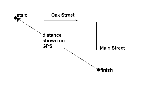
But what do you do if your destination is only known from a street map? The simplest way I found to proceed is to work backwards. In the hotel room, measure the straight-line distance between your destination and your starting point and write this number down. Upon arrival at your starting point, tell the GPS receiver to mark these coordinates. This is accomplished by holding down the "OK" button for a few seconds. You then hit "OK" again to approve the result. Then tell the GPS to "Go To" these coordinates. It should now be telling you that you have arrived. Not to worry, the GPS will soon be providing more useful information.
You look at the street map and see that your travels involve going east on Oak Street and then south on Main Street. The GPS displays a compass so you know east and south. Once on Main Street you are ready to use that distance you wrote down at the start of your adventure. Simply travel along Main Street until the distance back to your starting point equals the distance you measured from the map. Upon arrival, it might be good to record the coordinates with the GPS.
The above procedure may seem a bit odd. After all, the GPS can perform a projection from a given location. You simply tell it distance and angle and it will calculate a new location. My problem came in providing the angle. Even a small error in the angle can cause a large error in the result when the distance is large. Furthermore, you need to have a protractor on hand.